Help for BBBike extracts
The BBBike extract service lets you download free OpenStreetMap data for any area of the world: for Garmin GPS devices, smartphone apps, GIS software, web maps and your own projects.
Quick start
- Choose your area. Move the map to your desired area and click create. Adjust the bounding box or add points to define the area you want.
- Set up your extract. Select a Format, then enter the Name of area to extract and Your email address.
- Download your map. Click extract to start processing. You'll receive an email with the download link when your extract is ready.
- ⏱ An extract usually takes 2–7 minutes.
- ✉ We'll send the download link by email.
- ▢ Up to 24 million km² per extract. File size limits vary by format (128 MB to 1,500 MB).
- ↻ The OpenStreetMap data is updated every day.
Select an area
Move the map to the area you want, or use or search next to the name field to find a place. Then click the create button to create a bounding box on the map. To move or resize it, choose resize or drag polygon and click on the box. Drag the box to move it, or drag its corners to resize it.
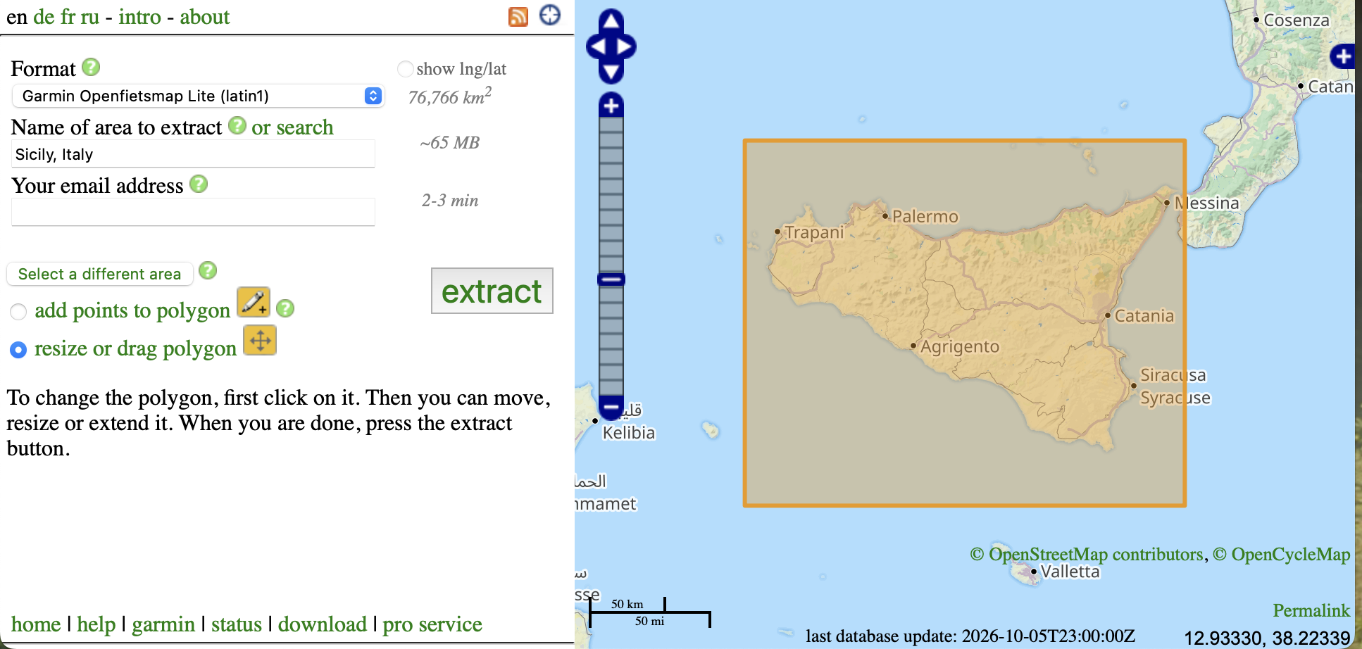
Want a polygon instead of a box?
First create a bounding box as described above. Then choose add points to polygon and click on the box. Drag the small handles in the middle of each edge to add new points. You can add as many points as you want:
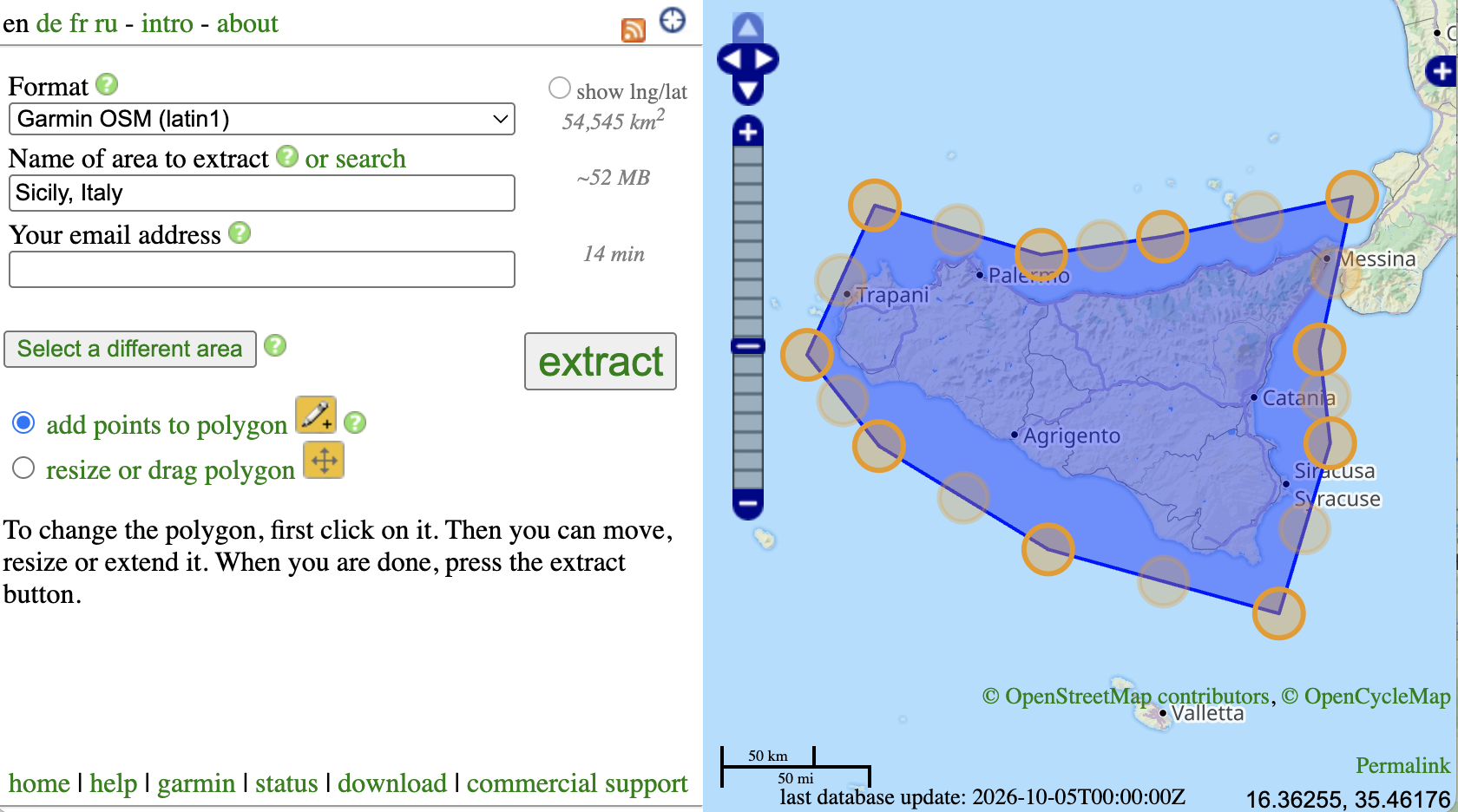
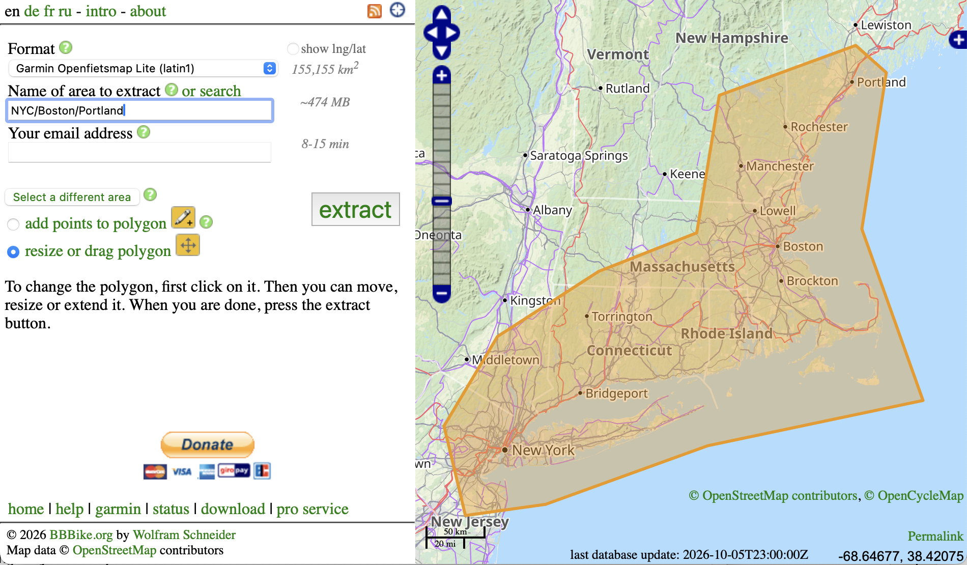
A polygon usually produces only a half to a third of the data of a rectangle covering the same area. Here is an example for a trip along the East Coast from New York City to Boston:
Need exact coordinates? Check show lng/lat and enter them directly. Valid values for longitude are -180 to 180, and for latitude -90 to 90.
Which format should I choose?
Choose the format by what you want to do with the data. The size column shows the approximate file size relative to the PBF extract of the same area (PBF = 1): if your area is 100 MB as PBF, it is about 43 MB as Garmin OSM and about 150 MB as Shapefile. Actual sizes vary by region and data content. The extract page shows the estimated size of your area for the selected format.
| Format | Use it for | Open it with | Relative file size (PBF = 1) | More |
|---|---|---|---|---|
| GPS devices and smartphone apps | ||||
| Garmin | Garmin GPS devices, with routing. Map styles: OSM, Cycle, Leisure (Freizeitkarte), Onroad, Ontrail, BBBike, Openfietsmap Lite and Full, OpenSeaMap and OpenTopoMap. | Your Garmin device. On the computer: QMapShack (FreeBSD, Linux, macOS, Windows), Garmin BaseCamp (macOS, Windows) | 0.04 to 0.61 |
Garmin help page (installation, map styles, UTF-8 and latin1) OSM Map On Garmin, Download screenshots |
| OsmAnd (OBF) | Offline maps on Android and iOS | OsmAnd (Android, iOS, Java desktop) | 1.40 |
osmand.net,
GitHub screenshots |
| Mapsforge | Offline maps on Android | Apps with Mapsforge support (Android, Java desktop) | 0.80 |
OSM wiki,
GitHub screenshots |
| GIS software | ||||
| Esri Shapefile, GeoPackage, GeoParquet |
Maps and analysis in GIS software | QGIS (FreeBSD, Linux, macOS, Windows), QField (Android, iOS) | 1.50 2.00 0.50 |
Shapefiles,
GeoPackage,
GeoParquet screenshots |
| Web maps and tile servers | ||||
| MBTiles | Vector tiles for apps and tile servers | MBTiles viewer, QGIS (MapTiler plugin), GDAL (FreeBSD, Linux, macOS, Windows) | 0.20 to 0.60 |
OSM wiki,
implementations,
Shortbread screenshots |
| PMTiles | Vector tiles for web maps without a tile server | pmtiles.io viewer | 0.20 to 0.60 |
OSM wiki,
GitHub,
Shortbread screenshots |
| Print and graphic design | ||||
| SVG | Posters, print and graphic design. Map styles: Google, Hiking, Mapnik, Night, Wireframe and Cadastre. Note: large SVG files (over 10 MB) may slow down or crash your browser or SVG viewer. | Inkscape (FreeBSD, Linux, macOS, Windows), Firefox, Safari, Google Chrome, Adobe Illustrator (macOS, Windows) | 1.14 to 3.82 |
Wikipedia,
OSM wiki screenshots |
| Raw OpenStreetMap data | ||||
| PBF | The standard format for OpenStreetMap software | Osmium and other OSM tools | 1.00 |
OSM wiki screenshots |
| OSM XML (gzip, xz), o5m (xz), CSV (xz) |
OSM tools and your own scripts | Osmium and other OSM tools, any text editor | 1.60 to 2.00 0.80 |
OSM XML,
o5m screenshots |
| Osmium OPL, GeoJSON, GeoJSONSeq, SQLite, text (xz) | Data analysis and your own scripts | Osmium, SQLite, any text editor | 1.50 to 2.00 |
osmcode.org screenshots |
| Other | ||||
| SRTM contour lines | Contour lines for Garmin, OsmAnd, PBF and OSM XML | see the format |
Wikipedia screenshots |
|
| BBBike (bbd) | The BBBike Perl/Tk route planner | BBBike | 2.20 | bbbike.de |
See the screenshots of all formats and map styles.
After you click extract
- You will get an email with the download link when your extract is ready, usually within 2–7 minutes. The extract system runs in a shared batch mode. If there are too many requests, it may take longer to process yours. Please be patient!
- You can see the status of your extract requests on the status page.
- Please use a meaningful name for the extract, so you can find it later in your inbox or on your computer.
- Older extracts expire and are deleted from the server after some time. If a download link no longer works, just request the extract again.
Check your download
You can verify a download with its MD5 checksum. Run one of these commands and compare the result with the checksum on the download page:
$ md5sum file.osm.pbf (Linux)
$ md5 file.osm.pbf (FreeBSD, macOS)
> certutil -hashfile file.osm.pbf MD5 (Windows)
Frequently asked questions
- I didn't get an email.
- Please check your spam folder first. You can also find your extract on the status page.
- I don't have a working email address, or can't access my email right now.
- Enter nobody as your email address, and find your extract on the status page.
- My area is too big.
- An extract can cover up to 24 million km². The maximum file size depends on the format (128 MB to 1,500 MB). Try a polygon instead of a rectangle, or a format with a smaller file size. Need even larger areas? See the extract pro service.
- My Garmin says "cannot unlock map".
- Some Garmin devices or firmware versions can't read maps with the Unicode (UTF-8) character set. The known workaround: choose the same Garmin format with "latin1" in its name. See the Garmin help page for details.
- How up to date is the data?
- The planet.osm database is updated every day, for all users. For details, see the BBBike planet.osm mirror.
- Do the extracts contain metadata?
- No, the extracts don't contain metadata such as version numbers, authors or timestamps. If you need to edit OSM data, please go to the OpenStreetMap website. Extracts with full metadata are available with the extract pro service.
- Are there ready-made extracts for countries or cities?
- Yes, see other extract services below.
Video tutorials
There are several YouTube tutorials on how to use the BBBike extract service for Shapefiles, Garmin, OSM and SVG, in English, French, Spanish, Russian, Portuguese, Thai and other languages. The videos are loaded from YouTube only when you click on them.
How to Download Free Trail Maps on Garmin GPS (English)
FREE World-Wide Garmin EDGE Maps // BBBike Updated Info! (English)
Download Shapefiles of Vector Data from OpenStreetMap, 1 min (English)
Create Custom City Maps in Canva (For Free), 10 min (English)
More videos
- Download Shapefiles from which area of the world / ArcGIS tutorial, 1 min (English/French)
- How to Download Shapefile from OpenStreetMap, 2 min (English)
- Adobe Illustrator tutorial | Road infographic template design, SVG, 3 min (English)
- World2Xplane Tutorial - How to build amazing overlays for X-Plane, 8 min (English)
- Tutoriel Impuls'Map Utiliser des données OpenStreetMap OSM dans QGIS, 6 min (French)
- Extraire les données Shapefile de n'importe quelle région en ligne (French)
- Shapefile mapas cartográficos (Spanish)
- Import Streets from OpenStreetMaps, 12 min (Russian)
- X-plane/World2Xplane OpenStreetMap, 6 min (Russian)
- Ortho4xp o melhor Tutorial+ World2xp e HD mesh V3, 5 min (Portuguese)
- Como baixar dados do openstreetmaps em varios formatos e usá-los no QGIS, 115 min (Portuguese)
- Steps to extract vector data from Web Map Service: bbbike, Shapefiles (Thai)
More Garmin YouTube videos are on the Garmin help page.
File size
The file size depends on the format. The table shows the approximate file size relative to the PBF extract of the same area (PBF = 1). Actual sizes vary by region and data content.
Show all size factors
| Format | Relative file size (PBF = 1) |
|---|---|
| PBF | 1.00 |
| OSM XML gzip | 2.00 |
| OSM XML xz | 1.60 |
| o5m xz | 0.80 |
| Osmium OPL xz | 1.70 |
| Osmium GeoJSON xz | 2.00 |
| Osmium SQLite xz | 1.50 |
| Osmium text xz | 1.80 |
| Mapsforge | 0.80 |
| Shapefile (Esri) | 1.50 |
| GeoParquet | 0.50 |
| GeoPackage | 2.00 |
| OsmAnd (OBF) | 1.40 |
| Garmin Cycle | 0.27 |
| Garmin Leisure | 0.55 |
| Garmin OSM | 0.43 |
| Garmin BBBike | 0.40 |
| Garmin Onroad | 0.04 |
| Garmin Ontrail | 0.13 |
| Garmin Openfietsmap Lite | 0.40 |
| Garmin Openfietsmap Full | 0.61 |
| Garmin OpenSeaMap | 0.40 |
| Garmin OpenTopoMap | 0.44 |
| SVG Google | 1.68 |
| SVG Hiking | 3.82 |
| SVG Mapnik | 3.34 |
| SVG Night | 1.14 |
| SVG Wireframe | 3.28 |
| MBTiles | 0.20 to 0.60 |
| PMTiles | 0.20 to 0.60 |
| BBBike Perl/Tk | 2.20 |
Other extract services
BBBike extracts by region
- Garmin and Mapsforge regions/countries, updated weekly
- More than 200 cities worldwide, ready to download
Other providers
- freizeitkarte-osm.de for Garmin and Android
- wiki.openstreetmap.org/wiki/User:Computerteddy for free Garmin maps, Europe and world
- wiki.openstreetmap.org/wiki/Planet.osm#Downloading for all formats
- download.geofabrik.de/openstreetmap for OSM, PBF and Shapefile, daily updates
- download.osmand.net/list.php for OsmAnd
Supported browsers
Any modern browser that follows the W3C standards:
- Firefox
- Safari, including mobile Safari (iOS)
- Google Chrome, Microsoft Edge, Opera and other Chromium-based browsers
JavaScript is required for the map and the place search. Cookies are optional and only used to save your preferences.
Terms of service
Map data © OpenStreetMap contributors.
Shuttle Radar Topography Mission (SRTM), by NASA, public domain.
The BBBike extract service is free of charge for general use by end users. There are no warranties; use it at your own risk. A fair usage policy applies.
BBBike professional plans
Want to use the service commercially, or need larger areas or extracts with full metadata? The BBBike extract pro service offers all of this, along with commercial support. See the BBBike extract pro service page for details and pricing.
Support the BBBike extract service